| |
Regional nature reserve and region of common importance
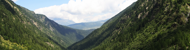
 Situated in the extreme east of the Orobian Alps (near Bergamo in Northern Italy) the nature reserve shelters the valleys of Brandet and Campovecchio, a twin valley of extraordinary beauty. Separated by a long mountain ridge the two valleys meet near the picturesque village of Sant’ Antonio. Sant’Antonio reached the peak of its development at the end of the 18th century and during the 19th century, when the interest for the exploitation of the mineral resources and the utilization of the forests and the pastureland were rising. Several melting furnaces are the remaining signs of the former mining industry. Particularly in the valley of Brandet they tell the story of a past full of efforts and sacrifices. Situated in the extreme east of the Orobian Alps (near Bergamo in Northern Italy) the nature reserve shelters the valleys of Brandet and Campovecchio, a twin valley of extraordinary beauty. Separated by a long mountain ridge the two valleys meet near the picturesque village of Sant’ Antonio. Sant’Antonio reached the peak of its development at the end of the 18th century and during the 19th century, when the interest for the exploitation of the mineral resources and the utilization of the forests and the pastureland were rising. Several melting furnaces are the remaining signs of the former mining industry. Particularly in the valley of Brandet they tell the story of a past full of efforts and sacrifices.
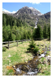
The nature reserve “Valli di Sant’Antonio” comprises the areas around the torrents of Campovecchio and Brandet up to their confluence near the locality of Sant’Antonio. From there on it encompasses the region close to the river as far as the locality Les. Its area is including 150 meters either side of the river bed as well as the rural settlements of Campovecchio and Brandet and the small district of Sant’Antonio. In the direction of the higher regions the nature reserve touches the pastureland of the alpine pasture Casazza in the valley of Brandet and the pastureland of the alpine pasture Enet in the valley of Campovecchio. In total it covers an area of 239 hectares. For directions visitors should refer to the D.G.R. n°4/53282 of 1990, March, 21st and pay attention to the signs in the area.
 The nature reserve “Valli di Sant’Antonio” is located inside the borders of the region of common importance of the same name (SIC codice natura 2000:IT2070017) and consists of the whole drainage basin of the valleys of Sant’Antonio, a total surface area of 4160 hectares. The nature reserve “Valli di Sant’Antonio” is located inside the borders of the region of common importance of the same name (SIC codice natura 2000:IT2070017) and consists of the whole drainage basin of the valleys of Sant’Antonio, a total surface area of 4160 hectares.
The altitude ranges from 1000m near Fucine (where the S. Antonio valley ends at the river Ogliolo) to high summits like the Mounts Torsolazzo (2604 m), Lorio (2674 m), Telenek (2748m), Sellero (2733 m), Culvegla (2613 m) and Borga (2734 m) which form the boundary of the drainage basin of Campovecchio. The Mounts Torsoleto (2705 m), Piz Volt (2641 m), Palone del Torsolazzo (2670 m), Zingo-Bernù (2597 m), Palone del Soppressa (2588 m) and the Palone di Bondone (2535 m) limit the drainage basin of the valley of Brandet. The two adjoining valleys run in south-north direction and unite in the Sant’Antonio valley near the village of the same name; therefore the slopes show the characteristics of an eastern and a western exposition with significantly varying habitats.
|
|