| |
Characteristics of geomorphology
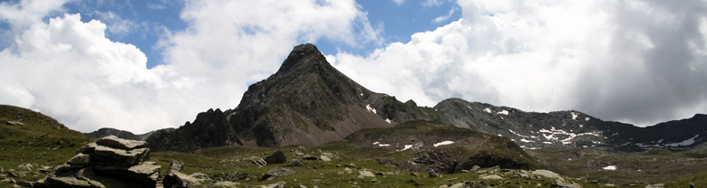
 The predominating substrate of the soil is determined by the rocks of silicate origin. In the higher regions the two valleys still show the typical U-formation, created by the glaciers of the ice-age, while in the lower regions, below 1300 m up to the meeting point with the river Ogliolo, the erosion, caused by the running water, has created the typical V-formation. In general the incline of the slopes is quite distinctive, the plainer regions are situated at the bottom of the valley, above the terrace moraines. Also situated there are the oldest rural settlements of Campovecchio and Brandet. Of great relevancy are the currents of water - they had been the real reason for the foundation of the nature reserve. The rivers Brandet and Campovecchio pass through the two principal valleys and unite in the Sant’Antonio valley at 1110 m above sea level, near the village of the same name. The higher situated part of the drainage basin of the Sant’Antonio valleys is located beyond the nature reserve but inside the region of common importance and accommodates lots of alp lakes which are important for the beauty of the countryside of the region. Amongst them, because of its size and importance, the principal lake is the Lago di Piccolo (2230 m). It is known for bearing the title of being the biggest natural alp lake of the province of Brescia and of the Orobian Alps. The lake is surrounded by a serial of smaller lakes, they all have the same glacial origin. Amongst them the most outstanding one is without a doubt the Lago di Culvegla (2290 m). The predominating substrate of the soil is determined by the rocks of silicate origin. In the higher regions the two valleys still show the typical U-formation, created by the glaciers of the ice-age, while in the lower regions, below 1300 m up to the meeting point with the river Ogliolo, the erosion, caused by the running water, has created the typical V-formation. In general the incline of the slopes is quite distinctive, the plainer regions are situated at the bottom of the valley, above the terrace moraines. Also situated there are the oldest rural settlements of Campovecchio and Brandet. Of great relevancy are the currents of water - they had been the real reason for the foundation of the nature reserve. The rivers Brandet and Campovecchio pass through the two principal valleys and unite in the Sant’Antonio valley at 1110 m above sea level, near the village of the same name. The higher situated part of the drainage basin of the Sant’Antonio valleys is located beyond the nature reserve but inside the region of common importance and accommodates lots of alp lakes which are important for the beauty of the countryside of the region. Amongst them, because of its size and importance, the principal lake is the Lago di Piccolo (2230 m). It is known for bearing the title of being the biggest natural alp lake of the province of Brescia and of the Orobian Alps. The lake is surrounded by a serial of smaller lakes, they all have the same glacial origin. Amongst them the most outstanding one is without a doubt the Lago di Culvegla (2290 m). |
|